The NASA Tropical Rainfall Measuring Mission (TRMM) satellite was launched in November 1997 and has been operating successfully since that time. The prime goal of TRMM is to provide remote sensing measurements of the perturbations to the large-scale balanced flow caused by tropical precipitating systems, which can be used to compare with predictions from climate models. For this purpose, the TRMM satellite carries a microwave imager (TMI) (similar to that which was aboard the University of Washington's (UW) Convair-580 in KWAJEX), a precipitation radar (PR), visible and infrared imagers, and a lightning detection system.
For more information on TRMM see http://trmm.gsfc.nasa.gov/.
The Kwajalein field Experiment (KWAJEX) was one of a series of experiments designed to provide radar measurements and in situ measurements from aircraft in conjunction with TRMM satellite overpasses and TRMM simulators on high flying aircraft. KWAJEX was unique among the TRMM field experiments in that it was the only one to be conducted over the tropical oceans.
In addition to providing data to test current algorithms for deriving cloud properties from TRMM satellite remote sensing measurements, KWAJEX was designed to provide data on the structure of tropical convective clouds and precipitation, which can be used for the development and improvement of numerical models of these systems.
For more information on KWAJEX see http://www.atmos.washington.edu/gcg/MG/KWAJ/kwajex.html.
(c) Location and Period of KWAJEX
KWAJEX was carried out in the Marshall Islands. The Operations Center, and the base for the three research aircraft (NASA's DC-8, University of North Dakota's Citation, and the UW Convair-580), was Kwajalein Island (9.05°N/167.20°E–see Figs. 1.1 and 1.2).
The period of the field study for KWAJEX was 25 July through 15 September 1999.
Figure 1.1. Aerial photo of Kwajalein Island, US Army Kwajalein Atoll/Kwajalein Missile Range. The locations of several primary KWAJEX resources are indicated.
|
|
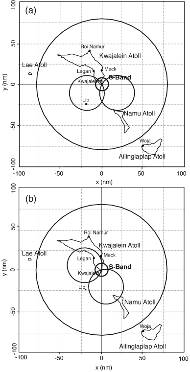
Figure 1.2. Location of islands with KWAJEX sensors. Also shown are the dual-Doppler lobes when the R/V Brown was (a) 40 km south (from 28 July-19 August), and (b) 40 km southwest (24 August-12 September) of the Kwajalein S-band radar. The outer circle is the 80 nm range ring around the Kwajalein radar. |
2. OBJECTIVES OF THE UW CONVAIR-580 FLIGHTS IN KWAJEX/TRMM
The main objecties of the UW Convair-580 flights in KWAJEX/TRMM were:
• To fly beneath the TRMM satellite to obtain in situ measurements on statiform and convective precipitation and cloud structures for comparison with the TRMM remote sensing Microwave Imager (TMI) and Precipitation Radar (PR).
• To fly beneath the NASA DC-8 aircraft to obtain in situ measurements for comparison with remote sensing measurments from the AMPR (downward-looking microwave radiometer) and the ARMAR (downward-looking Ku-band radar) on the DC-8.
• To obtain in situ measurments on the structures of tropical clouds in order to improve understanding of the physical mechanisms operating in these clouds.
The first and second of the above objectives relate to the testing and improvement of algorithms used for deriving cloud and precipitation properties from remote sensing measurements, and the third objective to improving numerical models of tropical clouds.
In addition to the three prime objectives listed above, some aerosol and trace gas measurements were made aboard the CV-580 for the purpose of supplementing the meager data available on aerosols and gases in the tropics.
The instrumentation aboard the UW Convair-580 for these studies is listed in Table 1. Not all of these instruments provided reliable data on all of the flights.
(Text continued on Section 4.)
Back to Table of Contents